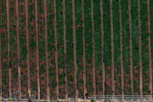

Unmanned aerial vehicles (UAVs) can collect imagery of the crops and fields they fly over and may be the way monitoring data could be captured in the future. IPM Advisor Chris Greer is exploring how UAV technology can be easily integrated into pest management programs. “Many people comment that it must be fun to pilot the UAV,” Greer writes in a recent article. “In reality, it is not as exciting as people think because the UAV is flying autonomously following a programmed flight plan. The pilot spends most of their time scanning the airspace for low flying aircraft and other obstacles to avoid. The real excitement for a scientist is the wealth of data collected by the instrumentation the UAV is carrying.”
Unmanned aerial vehicles and the images they capture could be used to test research hypotheses or inform decision-making for pest management. The data from multispectral, thermal, RGB (red, green, blue), and hyperspectral sensors can be used to monitor crop plant health. Thermal imagery can monitor plant water stress, and multispectral imagery can assess plant stress, such as nutrient deficiencies or disease infection.
Unmanned aerial vehicles and the images they capture could be used to test research hypotheses or inform decision-making for pest management.
Greer captured images of strawberry fields and could identify stressed and dead plants in certain areas of the field that later were confirmed by infield scouting to be severely affected by soilborne pathogens. Healthy plants absorb certain spectrums of light and reflect others. Unhealthy plants do the same, but at opposite spectrums than healthy plants. For example, healthy strawberry plants absorb red light and show up in images as a darker color.
“I do not believe remote sensing will ever be a replacement for on-the-ground scouting, historical knowledge, experience, etc. However, I view remote sensing as being complementary and having the potential to contribute to the knowledge base that informs the integrated pest management decision-making process,” states Greer in his article.
Greer sees spectral imaging data as another tool in the toolbox of monitoring. Imaging data could provide timely information, increase scouting efficiencies, detect pest issues earlier, and document pest movement over time. However, there is still a long way to go before these tools become more commonly used in all crops and for all pests.
Greer’s article: Greer CA. 2021. Multispectral imaging and its utility to an integrated pest management program. CAPCA Adviser Magazine XXIV(1): 24–28. https://capca.com/publication/adviser-magazine-february-2021/.
Long-Term Impacts
Typically, samples (e.g., data from 10 trees per orchard or 10 plants per block in a field) are taken from fields to estimate what is happening in the overall field. With multispectral imaging, data from an entire field can be analyzed by individual plant, individual bed, individual experimental unit, or individual block. In addition, temporal data that documents changes over time can be more easily captured throughout a production season or from season to season for perennial crops. It is anticipated that with more testing spectral imaging could be used to improve the decision-making process of integrated pest management.
